
€10,858.00 IVA Inclusa
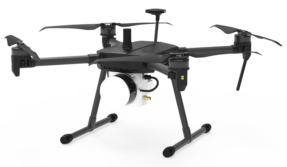
The professional 3D Lidar for drone
most compact and efficient on the market


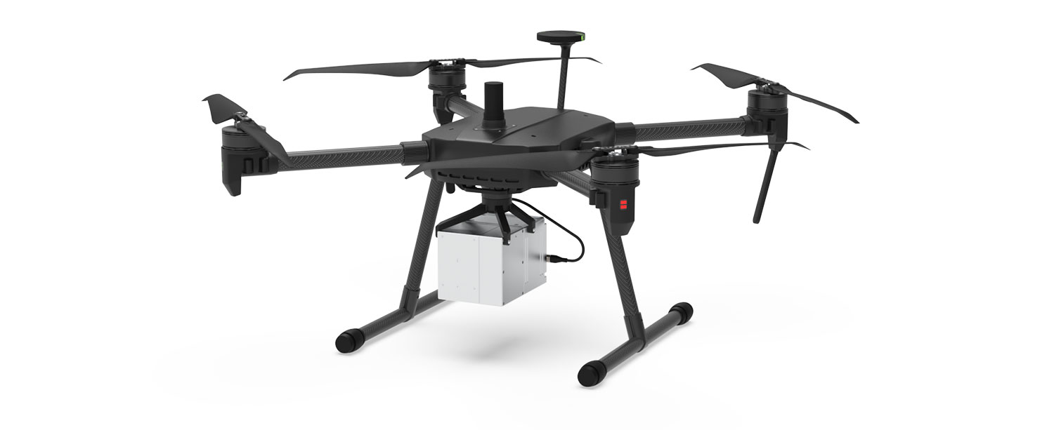
GS-100C+ combines a compact and lightweight design with detection range
and incredible efficiency combined with a price never seen before thanks to LIVOX technology.
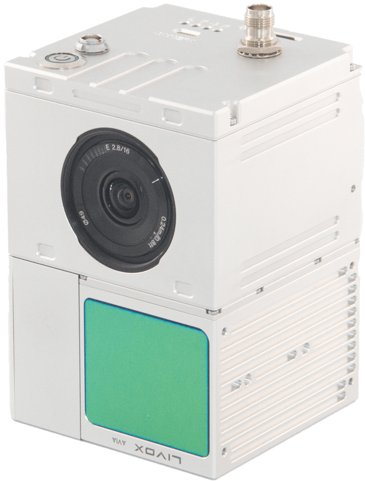
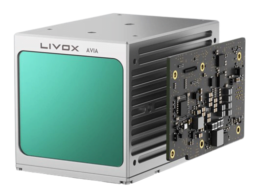
The GC100C+ includes a Livox Lidar module, a high-precision IMU and an integrated centimeter GPS system. GS100C+ is a complete, stand-alone solution compatible with any drone on the market that can capture complex structures by providing reconstructed models particularly
triple-echo
point rate
max
range
range
precision
max area
scan
circular
view
imu
sensor
Its design allows the device to be installed on any drone or ground vehicle.
Quick and easy to use, it is ready to scan within 2 minutes of being turned on.
The technical specifications of the GS100 3D Lidar make it the ideal partner for the
More demanding topographers looking for an accurate and reliable instrument.
GS100 is suitable for any application, depending on the vehicle on which it is mounted:
From a classical topographic survey to agro-forestry surveys.
– 240,000 points/second Single Echo
– 720,000 points/second Triple Echo
– Integrated 200hz IMU by GSN
– Fov 70°
– Maximum measuring range 450m*
– L1-L2 GNSS integrated (2-5cm accuracy)
– 905nm Laser Class1 (IEC 60825-1:2014)
– Integrated control unit to synchronize sensor data
– RGB camera Ready(Sony Alpha 24-61mp)
– Compact and lightweight (1036g)
– Sturdy aluminum shell Compatible with Multirotors, Fixed Wings, Vtol and Ground Vehicles
Lidar framing with:
– results of point clouds effective up to 100 percent
– Detection range:
– 450 m (80% reflection, 0 klx)
– 190 m (10% reflection, 100 klx)
– Effective Points: 240,000 points/s
– Supports 3 returns [3]
– Type of Scan: repetitive, non-repetitive
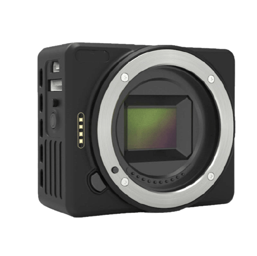
– Brand : Sony
– Model : Sony A6000 – A7RII
– Sensor: APS-C – Full Frame
– Resolution : 24 – 42mp
– Lens : Low distortion 35mm
– Mechanical shutter
– Memory : Integrated 64gb
– Trigger : by time/distance
– 1 x gAirHawk GS-100C+ Lidar
– 1 x GNSS Antenna L1-L2
– 1 x Micro SDCard 128gb
– 1 x USB flash drives 8gb
– 1 x Software Usage Manual
– 1 x Video Tutorial
– 1 x gAirHawk, GNSS post-processing and inertial data
– 1 x Shuttle for cloud georeferencing
– 1 x 1-year warranty
– 1 x Online technical support
Caratteristiche tecniche |
Item Name |
System Parameters |
|---|---|---|
|
GS-100G Parameters |
Weight |
0.750g |
|
Lidar Unit (Livox avia) |
Measuring Range |
190m@10% Reflectivity, 260m@20% Reflectivity, 450m@80% Reflectivity |
|
POS Unit |
Update frequency |
200HZ |
|
Pre-processing software |
POS software |
Output information: position, speed, attitude |
|
Point cloud processing software |
The third-party software |
Cloud Compare, LiDAR_Mate, Point Cloud Catalyst, Point Cab, TerraSolid, TopoDoT |
|
Camera (GS100G only) |
Camera model |
A6000 Custom with low distortion 35mm lens |
L’obiettivo di industria 4.0 è quello di incentivare le aziende italiane che investono in beni strumentali per migliorare, attraverso la digitalizzazione, i propri processi produttivi.
Questo si traduce in vantaggi Fiscali da una parte e Produttivi dall’altra.
DroneBase ti mette a disposizione un Consulente Esperto
in grado di consigliarti il prodotto più adeguato alle tue necessità
e rispondere a tutte le tue domande.
Inserisci i tuoi dati quì sotto, il nostro consulente ti
ricontatterà al più presto e ti fornirà tutti i dettagli!

© 2023 all rights reserved
WhatsApp us
Grazie per il tuo interesse nelle nostre soluzioni
Compila il Form qui affianco e sarai contattato
da un nostro Consulente Esperto che ti fornirà
la Migliore soluzione per la Tue Necessità!
Grazie della tua fiducia.
Team DroneBase
Thank you for your interest in our solutions
Fill out the Form opposite and you will be contacted
by one of our Expert Advisors who will provide you with
The Best Solution for Your Need!
Thank you for your confidence.
Team DroneBase
Thank you for your interest in our applications.
Fill out the Form next to it to receive:
Request a consultation with one of our Experts to Point you to the Best Solution for Your
Necessity!
Thank you for your confidence.
Team DroneBase
Thank you for your interest in our applications.
Fill out the Form next to it to receive:
Request a consultation with one of our Experts to Point you to the Best Solution for Your
Necessity!
Thank you for your confidence.
Team DroneBase
Thank you for your interest in our applications
Fill out the Form opposite and you will be contacted by one of our Expert Consultants who will provide you with the Best Solution for YOUR NEEDS!
Thank you for your confidence.
Team DroneBase
Thank you for your interest in our Video Surveillance solutions
Fill out the Form opposite and you will be contacted
by one of our Expert Advisors who will provide you with
The Best Solution for Your Need!
Thank you for your confidence.
Team DroneBase
Thank you for your interest in our applications.
Fill out the Form next to it to receive:
Request a consultation with one of our Experts to Point you to the Best Solution for Your Need!
Thank you for your confidence.
Team DroneBase
Thank you for your interest in our applications.
Fill out the Form next to it to receive:
Request a consultation with one of our Experts to Point you to the Best Solution for Your
Necessity!
Thank you for your confidence.
Team DroneBase


Reviews
There are no reviews yet.