Efficient
Acquire data faster than traditional methods

Precise
The drone's precise positioning and rangefinder systems ensure high-precision measurements

Cheap
UAV surveys are more cost-effective than traditional methods

Sure
The integrated system can be used in hazardous and unsafe environments without compromising the safety of personnel

Precise
GNSS RTK positioning systems and Radar rangefinder ensure accurate measurements at very low altitude

Smart
Total integration between sensor, drone and software ensure precise and intuitive operation


Effective
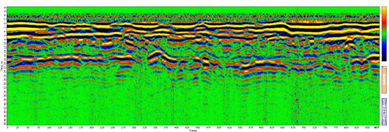
All Drone + GPR or Magnetometer Kits are designed to acquire large areas better and faster without interrupting work or site activities
Precise
Calibrated Sensors combined with GNSS RTK Systems always ensure the highest level of precision with accuracy down to the centimeter
Safe
Difficult to access or dangerous areas will no longer be a problem with our fully integrated Drone GPR or Magnetometer solutions.
Competitive
Drone Geophysical Survey provides reduced field acquisition time and drastic reduction in post processing time allowing you to be more competitive